Understanding the ground beneath Missoula means recognizing that soil conditions can shift dramatically between the historic downtown near the Clark Fork River and the newer developments climbing into the Rattlesnake Valley. Downtown, you hit the coarse alluvium and cobbles that make up the Missoula Valley aquifer, while areas near the base of Mount Sentinel often hide the famous Glacial Lake Missoula varved silts and clays. These rhythmically bedded sediments behave nothing like the gravels just a mile east. When a project calls for a deep excavation, whether for a parking structure on Broadway or a utility vault near the University, the grain-size distribution of these lakebed soils becomes the first real clue about how the cut will perform under load and what kind of earth pressure we need to design for. It is not just about depth; it is about knowing which Missoula soil unit you are standing on and how it reacts when you remove the overburden that has been holding it in place since the last ice age.
The varved clays of Glacial Lake Missoula demand a base stability check that gravelly soils just do not bother with.
Local considerations
Missoula grew fast after the railroad arrived in 1883, and a lot of the early industrial fill along the north side of the tracks got placed without any compaction control, right on top of the native floodplain silts. That legacy means a deep excavation in the old warehouse district can encounter pockets of ash, brick rubble, and decayed organics that behave unpredictably when you expose them to air and moisture. The biggest technical risk is not just a sloughing wall; it is the progressive loss of ground that can undermine an adjacent street or a neighboring shallow foundation. We spend a good chunk of the design phase modeling the construction sequence to see where stress relief will concentrate, especially at the toe of the cut. If the surcharge from stored materials or a crawler crane is not factored into the shoring design, the bending moments in the soldier piles can exceed what the section was sized for, and the whole system can drift inward before anyone notices the crack opening at the surface.
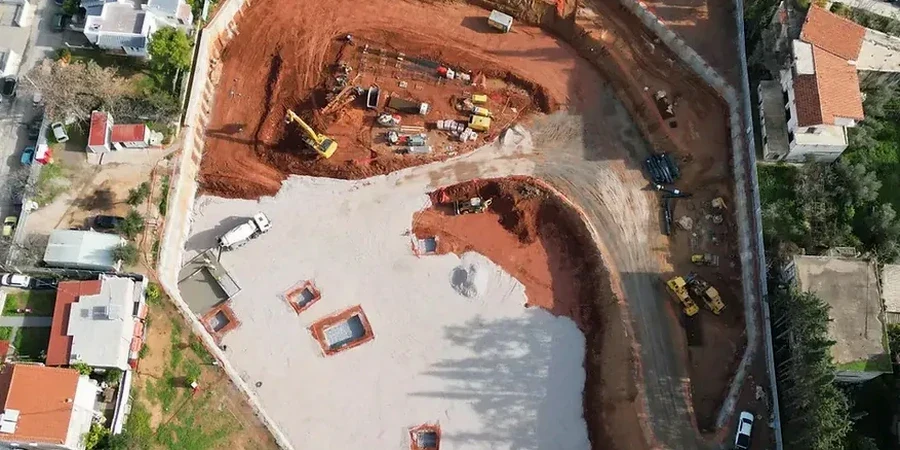
Questions and answers
What does a deep excavation design typically cost for a Missoula commercial project?
For a typical Missoula commercial deep excavation, the geotechnical design package including shoring calculations, dewatering analysis, and monitoring plan runs between US$2,030 and US$8,990 depending on the depth of the cut, the complexity of the soil profile, and whether permanent retaining elements are involved. A straightforward soldier pile wall with a single tieback level for a 20-foot cut in granular Missoula Valley soils sits near the lower end, while a multi-level braced excavation in soft Glacial Lake Missoula clays with adjacent historic buildings pushes toward the upper range.
Why are Glacial Lake Missoula sediments so problematic for deep excavations?
The varved silts and clays deposited by Glacial Lake Missoula are rhythmically bedded, meaning thin layers of silt alternate with clay layers. This fabric creates anisotropic strength and drainage behavior. When you excavate into them, the silt laminae can act as drainage paths that bleed water into the cut face, while the clay laminae control the undrained shear strength that governs basal stability. The material also tends to soften and lose strength quickly upon stress relief, so the excavation sequence must limit the time any unsupported face is left open.
Does Missoula require a geotechnical report for excavation permits?
Yes. The City of Missoula Development Services division requires a geotechnical report prepared by a licensed professional engineer for any excavation deeper than eight feet or that will be open longer than 14 days. The report must address slope stability, shoring design, groundwater management, and potential impacts to adjacent properties and public rights-of-way. We coordinate directly with the city review team to ensure the submittal meets the current IBC chapter 18 and local amendment requirements.
How do you handle high groundwater during excavation near the Clark Fork River?
Near the Clark Fork, the water table often sits within six to ten feet of the surface, and the alluvial gravels are highly permeable. We typically design a cutoff wall using interlocking sheet piles driven into the underlying lower-permeability lakebed sediments to reduce inflow, combined with a deep well system or well points just outside the excavation perimeter. The dewatering analysis predicts the drawdown curve so we can identify any risk of settlement at nearby foundations before pumping starts.